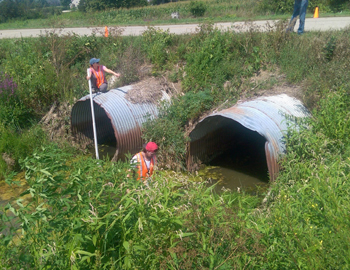
MiCorps offers grants and training for groups in Michigan to assess the condition of bridges and culverts crossing rivers and streams. Poorly designed or aging bridges and culverts are a major source of degradation to our waterways. These road/stream crossings cause stream sedimentation due to erosion, increase water flow, and block fish passage when improperly sized. Finding and rating poor road crossings are the first important step in getting them fixed.
The Clinton River Watershed Council, Calhoun Conservation District, Van Buren County Road Commission, and Macatawa Area Coordinating Council (MACC) have all completed this project with MiCorps funding over the last couple of years. The White River Watershed Partnership and the St. Joseph County Conservation District have active projects right now.
MACC recently completed their MiCorps grant and were able to assess 57 locations in a 13-month time span; however, they believe strongly in the value of the data and intend to continue the work for another 10 years until all of the 566 road-stream intersections in their area have been assessed. The MACC has partnered with local government agencies that will directly use the results of the assessments in construction and restoration projects including: The Allegan County Road Commission, Allegan County Drain Commissioner’s Office, and Ottawa County Water Resources Commissioner’s Office.
Check out this amazing post from the U.S. Fish and Wildlife Service. It goes into greater detail about the impacts of poorly designed river-crossings. Don’t miss the video showing a road getting washed away!
